
Cardwell Junction
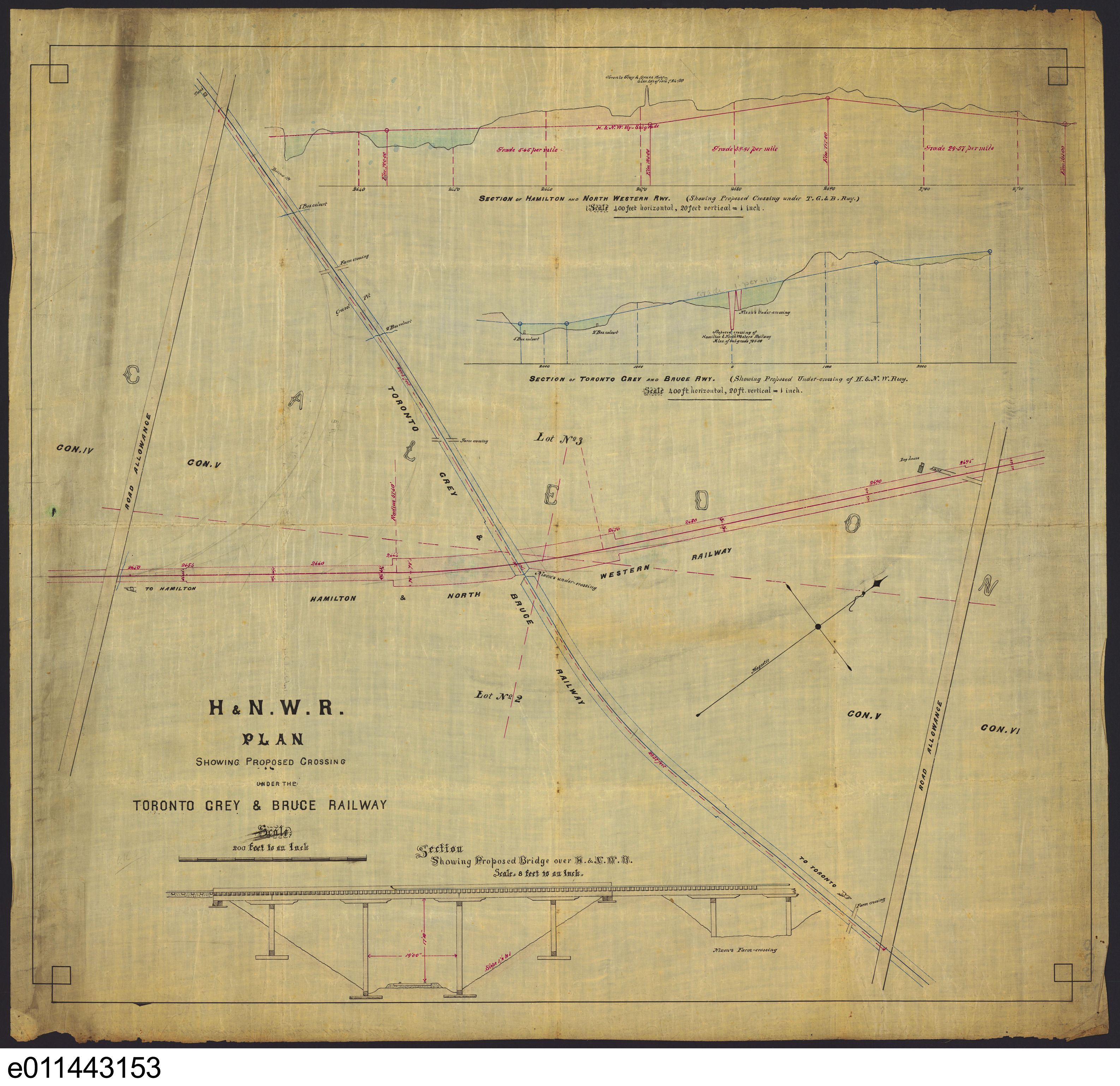
This chart must have been one of the earliest, if not the earliest, to speak to the changes that were to come to Cardwell Junction. 1876-1877. It speaks to the proposed TG&B underpass, and confirms the bridge design that was in fact installed. It also confirms the existence of the TG&B water tank at the 4th Concession in the top left corner of the chart, as well the farm crossings along the route of the TG&B. Library Archives Canada (LAC) e011443153.
GTR drawing office map dated July 27, 1895, from the Library Archives Canada. Notes: (1) It shows two crossovers on either side of the station. (2) It specifies the long GTR spur to the north of the GTR's mainline from the south switch of the wye to the boundary of the CPR's property. (3) Close-up of the station, from south to north - refreshment room, waiting room, office, baggage room. (4) Both the H&NW and the TG&B spurs served gravel pits. There is no evidence that they were used for passing trains.

GTR drawing office map dated Aug 7, 1903 at the McMaster University Map Collection. Note: (1) the long CPR spur from the north switch of the wye to the north edge of the GTR underpass. (2) The GTR spur to the north of the GTR's mainline from the south switch of the wye to the boundary of the CPR's property. (3) Both of these spurs served gravel pits. There is no evidence that either was used for passing trains.
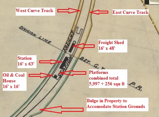
Annotated 1903 map. Note: Subsequent research has confirmed that the building designated as an "Oil & Coal House" was in fact a water closet. Courtesy Ralph Beaumont.
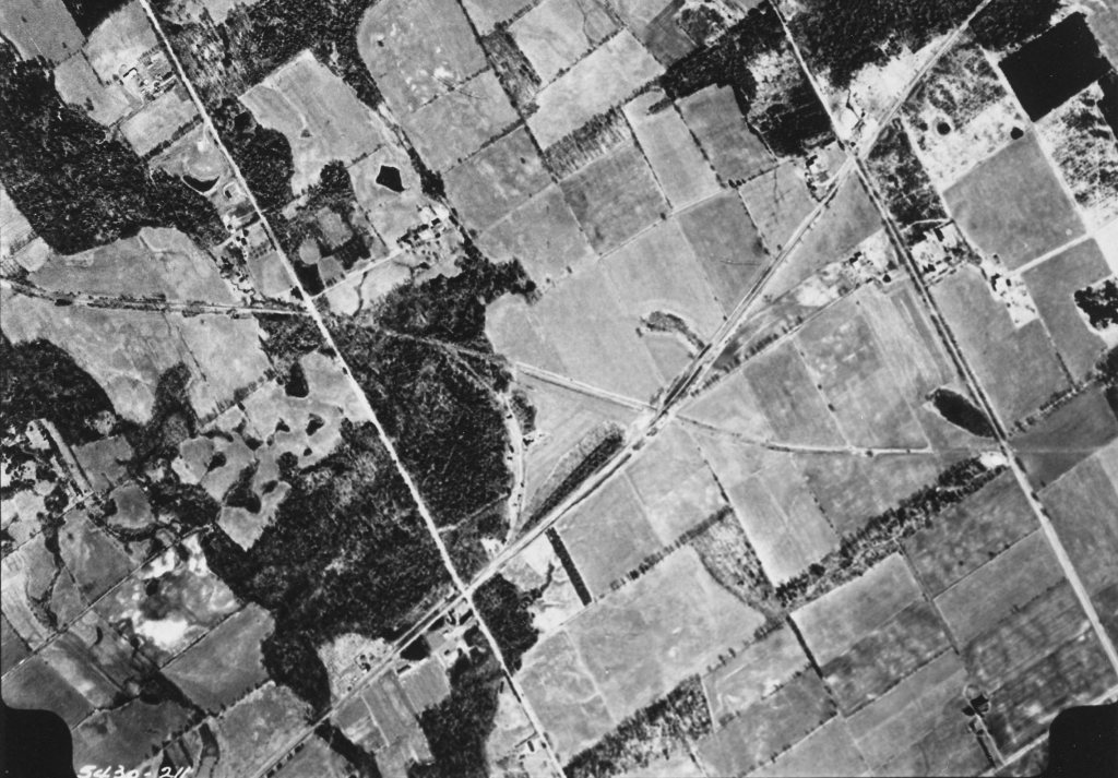
Cardwell Jct. aerial view, Spartan Air Services Ltd. photo, Peel Region Archives 5430-211
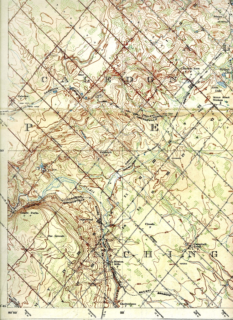
Bolton 30M13 1914 Dept Militia and Defence

Cardwell Jct. Right-Of-Way CNR Real Estate Department. Looking south.
Foreword
This page has come together as a result of painstaking additional research by Ralph Beaumont (author of Steam Trains to the Bruce [1977] and Thomas F. McIlwraith (author of The Toronto, Grey & Bruce Railway 1863-1884 [1963], as well as from input from the records of the late Peter Elms, a long-time resident of Caledon East, who took an interest in local railway history in general, and that of Caledon East and Cardwell Junction in particular.
From a railway research perspective, at Cardwell Junction two major mysteries lingered:
- Was there a connecting curve between the two pioneer lines?
- Was there a station (or more than one) there, and if so, where?
Many junctions have faded into obscurity, but in the era of railway dominance (arguably at least until the Great Depression), Cardwell was one to do so early on, and under circumstances that led to speculation for many years after its disappearance. A factor in that was its relative remoteness in a rural setting.
Cardwell – the Name
"The county of Cardwell consists of four townships, Albion, Caledon [Simcoe County], Mono and Adjala [Peel County]. The county was only made for political purposes and does not interfere with the workings of the different counties to which the townships composing the constituency of Cardwell belong." [Peel County Atlas 1877.]
Cardwell County was created at the time of Confederation in 1867 as federal and provincial electoral districts, lasting into the very early 20th century, and then being abolished. Cardwell Township in Muskoka Lakes was named after Edward Viscount Cardwell, British Secretary of State, and it is likely that the name was similarly adopted, as naming places after British Royalty and prominent UK politicians was popular in the day.
Junctions in general
With the explosion of railway-building in the 19th century, it was entirely expected that as the many competing lines criss-crossed the countryside, there would be many junctions to come into being.
Junctions: are generally of three basic types:
- A simple diverging switch
- A single or double crossing
- A single or double crossing with one or more connecting loops
Coincident with the applicable formation, the railways of the day followed a protocol. This was that the railway that was creating a junction, would be financially responsible for the track alterations and the necessary protection of trains; which often included a signal tower, but certainly an attendant in control of movements over the crossing.
Question 1 – Was there a connecting curve?
With the information that has "come to light" in the past decades, that seems to be an obvious question to ask - and one that can be resoundingly answered today.
The first railway to bisect the area was the Toronto, Grey & Bruce, in its bid to reach Orangeville in 1871. Faced with a stiff gradient from Mono Road to Caledon Village, this line was already on an embankment shortly after leaving Mono Road, in order to gain altitude in the approach to its ingenious (but subsequently discredited) Horseshoe Curve a little further north.
An early, if not the first, clue that there had been something more to Cardwell than a simple over/underpass between two railways appeared in Thomas McIlwraith’s 1963 work to the effect that upgrading was being done in 1881 which included “$2,500 being the half-cost of a junction with H&NW railway" [p 21] and further referred to a connection being "made with the Hamilton and North Western at Cardwell, where joint station facilities were located on the curve on the northwest of the intersection". [p 23]
It was in 1877 that the Hamilton & Northwestern Railway, which was making its way north from Georgetown into Simcoe County on its way to Barrie, needed to cross the TG&B line. The H&NW chief engineer reported to his Board of Directors in 1877 that “at the crossing of the T., G. & B. Railway the ground is favourable for an undercrossing, and I have made arrangements for crossing in that manner”. That certainly would have been the case, since the TG&B was, as noted, already on an embankment.
Railway construction, as in the business world today, was also one of politics, intrigue, alliances, rivalries, and hard financial realities. By 1880, the TG&B was in serious financial difficulty, partly because of the prolonged 1870s recession, but more importantly because of a pressing need to convert from its narrow gauge of 3' 6" to the standard gauge of 4' 8-1/2".
By 1880, the TG&B’s situation was critical. Its directors resigned and the TG&B was placed in the hands of its bondholders, one of whom was William Hendrie, a railway contractor and a prominent director on the Board of the Hamilton & Northwestern. While the H&NW was nominally still an independent road, the Grand Trunk Railway already had a significant presence on the H&NW board as well as running rights over H&NW rails. The GTR undertook to finance the re-gauging, in return for a share of the subsequent revenues. This deal also included an interchange track at Cardwell, with the $5,000 cost to be borne equally by the TG&B and the H&NW. Each railway owned one-half of the new connecting loop that provided for direct access from the GTR’s operations in Hamilton to Owen Sound. The re-gauging of the TG&B was completed in late 1881.
At the time Hamilton’s Other Railway was researched in the 1990s, if that was not known anywhere earlier, three items of “hard evidence" were at hand as to the existence of a connecting curve:
1. An aerial photograph from the Peel Region Archives, showing the unmistakable outline of such.
2. A photograph from the Peel Region Archives showing trains standing at the upper part of the unmistakable location of a connecting curve.
3. An excerpt from the Toronto Globe of July 10, 1882):
"In response to an invitation by the President and Directors of the Toronto, Grey & Bruce Railway, a large number of the leading merchants of Toronto and Hamilton proceeded on an excursion on that line of railway to Owen Sound ... The excursion party left [Toronto] Union station shortly after eight o’clock, and at the Caledon Junction, situated at the foot of the Caledon Hills, made a stoppage [sic] for the Hamilton excursionists, who came on the Hamilton & North-Western from that city. It is a noteworthy fact that this was the first time that a train passed direct from Hamilton to Owen Sound ... The two roads formerly intersected, but it is only within the past few days that a junction was effected ... "
Since that time, various maps and deeds have come to light - it was all a matter of looking in the right places - the trick all along was knowing where to look.
Yes, there definitely was.
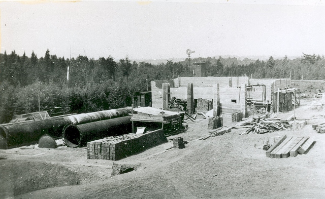
Contemporary pictures are scarce. The Bowlby Sand Lime and Brick Co. (1910 to 1919.) Peel Art Gallery Museum and Archives, Peter Elms Collection.