
Lindsay, Bobcaygeon & Pontypool Railway
SUMMARY HISTORY
Railway development in Canada began in earnest in the 1850s with a proliferation of locally-sponsored "pioneer" railways, but the advent into southern Ontario in the mid-1850s of the Grand Trunk Railway, and the emergence of the weighty Great Western Railway as competition to be reckoned with in south-western Ontario, set the stage for a battle for Ontario railway monopoly that seemed to be inevitable when the Grand Trunk finally swallowed up the Great Western in 1882.
At that point the only major independent road left was the Northern & North Western Railway, with a directorship that was equally split for the interests of the Grand Trunk, and the emerging Canadian Pacific Railway. The CPR had its own ambitions for becoming Canada's national railway, and had just burnished its claim to entitlement by reaching the west coast, and was now working on reaching the east coast, - well, at Saint John, New Brunswick at least. Its weak link was its lack of penetration into manufacturing-rich southern Ontario.
The Grand Trunk had seen the threat, and by means of its newly-engineered control of Cox's Midland Railway of Canada empire, had hoped to have establish a bulwark against the CPR's intended thrust into the heartland of Ontario in 1884 by means of its cat's-paw Ontario & Quebec Railway (O&Q) from Montreal through Peterborough to Toronto. Its original charter was granted as early as 1871, and was amended in 1881 to permit it to build into
Another "Laidlaw"' line was the Credit Valley Railway, which amalgamated with the O&Q on November 30, 1883. Its importance to the CPR was CVR's line to St. Thomas, effectively a springboard for the CPR into southwestern Ontario.
On January 4, 1884 , the O&Q was leased to the CPR for 999 years, and as of May 5, 1884 , trains were running between Toronto and Smiths Falls. The
Lindsay, Bobcaygeon & Pontypool Railway
Charter:
Dominion 53 Vic Cap 55
1890 Incorporation to build from at or near Pontypool, Durham County, Ontario, to Lindsay and Bobcaygeon, Victoria County etc etc
1904 Privy Council - Approval of lease to the CPR.
In 1890, Bobcaygeon’s predominant lumber business begun by Mossom Boyd in 1846, and carried on by his sons, agitated for and obtained a charter for the Lindsay, Bobcaygeon, & Pontypool Railway (LB&P), initially for the transport of lumber, but as that business faded, as a supplement to the existing steamer network on the local lakes and rivers. Construction began in 1901 and the line was opened in 1904. It branched off north at Burketon (west of
The only real engineering issues were to cross the Emily Creek outlet at Kenwood Beach and the Little Bob Channel on entry into Bobcaygeon. The former was accomplished with a low trestle, and the latter with a swing-bridge, which remained in service as a road bridge for over 40 years after the discontinuation of service. The original entry into Lindsay was planned to be along the west side of what is now CKL 36, with a spur to serve Lindsay. This the
The original segment between Burketon Jct., Nestleton, Janetville (Viewlake) and Lindsay Jct. (the last created by 1912 with the newer shorter connection to
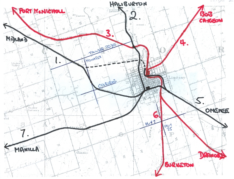
Railways emanating out of Lindsay. The LB&P is ## 4 and 6.
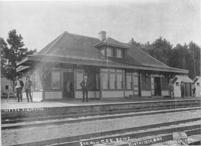
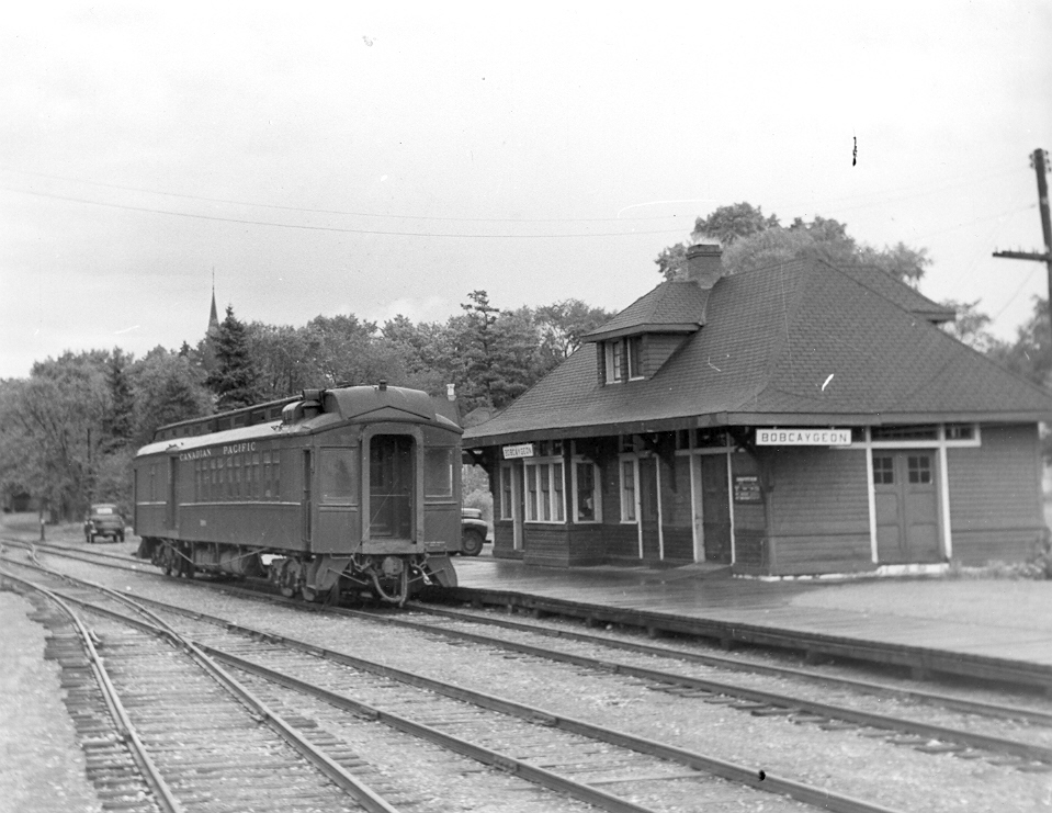
Bobcaygeon station, photo believed to have been taken at or around completion in 1904. Bobcaygeon Public Library
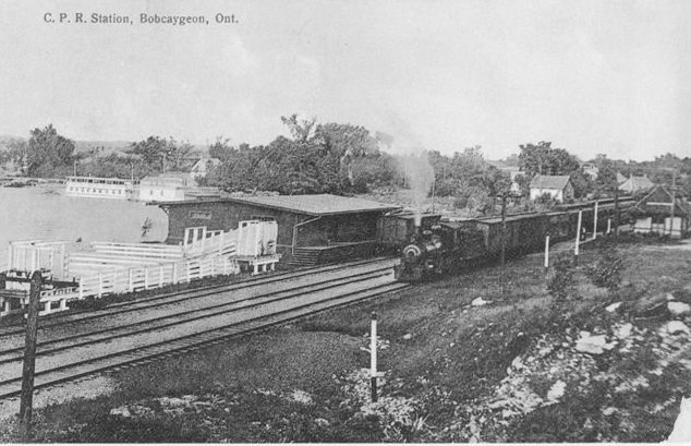
Bobcaygeon panorama. 1914. Harry Oudenaren Collection
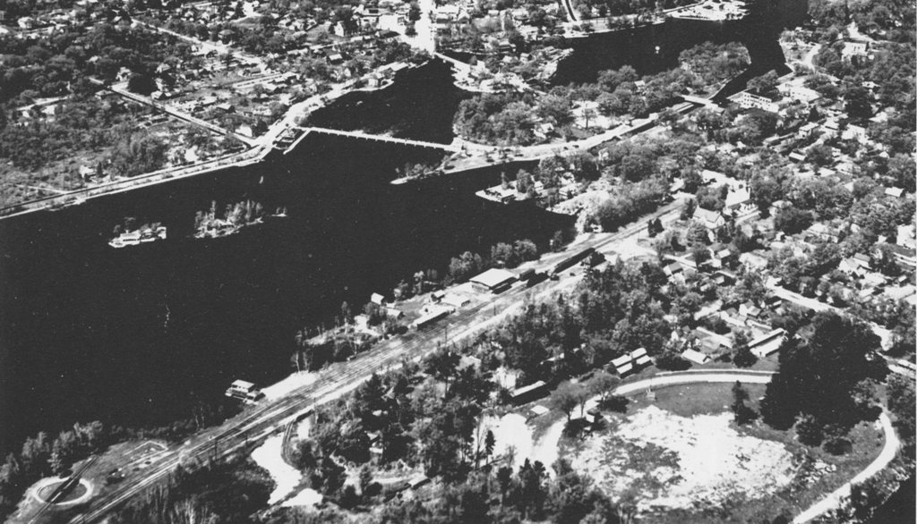
Bobcaygeon aerial view. 1955. Harry Oudenaren Collection
The combine car spotted at the Bobcaygeon while the engine attends to some switching. 1957. James A Brown photo

Bobcaygeon station in 1963. It was subsequently sold, and moved to the west side of Pigeon Lake. Whatever the plans for it were did not come about, and it was eventually demolished. Ray Corley photo

CPR #434 being turned on the Bob armstrong table. Date and photographer not known

The Mixed is on its way back to Lindsay, crossing the little Bob Channel. The swing-bridge base can be clearly seen. 12 July 1957. John Rehor photo

It is 2008, and CKL Road 24 is due for renewal. Looking west on the little Bob Channel side

A close-up view of the swing bridge pedestal that is still in position, although the bridge has not moved for years. Now about to be replaced, because of concern for structural failure. In place for 104 years. 2008.

Looking southwest towards Dunsford in 2017 at the junction of CKL Roads 24 and 36. The large advertising sign sits on the former right-of-way.

CPR # 434 with its light load has just crossed CKL 36 and is heading towards Dunsford. August 8, 1958. John Rehor photo, Keith Hopkin Collection

Dunsford station in the earler days. Looking north. Tony Bock Collection

CPR #434 southbound at Dunsford with a "caboose hop". 17 July 1958. Al Paterson Collection

Dunsford CPR in Aug 1961. The weeds testify to abandonment. Photographer not known. Larry Murphy Collection

Looking southwest from Dunsford in August 1961. Photographer not known. Larry Murphy Collection

Dunsford, moved away. The only remaining station, in retirement in 2009.

CPR # 434 with its caboose hop. Identified by Larry Murphy as being just north of the automotive plaza (where St. Dave's diner burned down) on the north side of CKL 36. No date. The train is heading to Lindsay. Don Wood photo, Ian Wilson Collection.

Looking west into Lindsay from CKL 36 where the LB&P crossed at the automotive plaza where St. Dave's Diner burned down. 2017.

Looking east along the r-o-w towards CKL 36 in the vicinity of St. David Street, Lindsay. 2005.

A long-forgotten spur to the south of the r-o-w in the vicinity of St. David Street, Lindsay. 2005.

The rails peek out at St. Paul Street, Lindsay, looking east out to Bobcaygeon. 2005.

This is not 434, but 487 arriving at Lindsay from Bobcaygeon in more prosperous days. 1953. Larry Murphy Collection

The tracks have gone. Approaching the Lindsay station area from Bobcaygeon in 2010.

Lindsay CPR 1904. Could have been at opening time, and/or a crowd for a large political picnic somewhere..

A busy Mixed arriving from Bobcaygeon. Ross Gray Collection

Mixed arriving from Bob. 1906.

A view from Queen Street, showing off the well-manicured garden that the railway always encouraged. Ca 1910. Ross Gray Collection

A rather "heavy-of-heart" scene in 1914, as Lindsay's flower of youth embarks for Montreal and overseas.

A well-publicized portrait of the handsome witch's hat station, as CPR #484 steams in with its caboose hop. 1957. Robert J Sandusky photo

A 1961 portrait from the Al Paterson Collection.

Looking across the site of the CPR freight shed towards Bond St. E.. off Lindsay Street North. 2010.

The CPR station site looking straight towards Queen Street. 2010.

Looking north towards the CPR station area from Queen Street. 2017. The site now sports community housing, and all railway vestiges have gone.

Panorama view along the Scugog River. 1930s. Charles Cooper Collection

At the Lindsay "iron bridge" just north of Lindsay Junction. CSMT Collection

Lindsay Junction 1917. Charles H. Heels Collection

Lindsay Junction 2010. The "station" was approximately where the walking stick is embedded. Looking south. The LB&P line branched off at the right hand edge, and was still just discernible in the scrub.

From Lindsay Junction, the LB&P cut across River Road at several locations, and the roadbed is still observable at a number of crossing points.

Looking south at the former location of Ops station. See black dot on map.

Looking north off River Road at what has become the driveway for a private residence. See middle black dot on the map.

Looking north from River Road at Clabo station. See black dot on map.

Southbound train at Janetville station, perhaps 1920s.

Genertal view of Janetville station, looking more or less south.

Janetville station, by then known as Viewlake, in retirement about 1977. It was subsequently demolished in a fire department fire-fighting exercise.

The Janetville/Viewlake station appears at the right hand edge in this postcard view per this H R Oakman photo, published by the Peterboro Postcard Co.

Nestleton Station in the 1920s, looking south.

Nestleton Station, looking north. 1930s. Ross Gray Collection

Nestleton Station, looking south. 1930s. Ross Gray Collection

Nestleton Station in retirement as a private dwelling 1970s. Since demolished. Charles Cooper Collection

DND "D02 1930 Scugog" map of Burketon when it was a busy junction station.

Commentary on the following pictures by Danny Allen, the photographer.

Entrance to wye south of Boundary Road, lk S 2019 Danny Allen photo

Burketon Jct point where the wye begins looking S 2019 Danny Allen photo

Burketon Jct east leg of wye 2019 Danny Allen photo

Burketon Jct west leg of wye 2019 Danny Allen photo

Looking from the former Burketon station area towards Peterborough. Danny Allen photo 2019.

Approximate point where west leg of wye branched off from mainline. Looking east. Danny Allen photo 2019

Burketon (formerly Junction) station in 1968. James A. Bown photo
STATIONS
1904-1932
1056 00.0 Burketon Junction
973 5.9 Nestleton
869 08.3 Scugog^
09.2 St. Christopher^
869 11.6 Janetville
832 14.8 Clabo
829 17.4 Ops^
837 21.2 Lindsay Junction
1932-1957
852 00.0 Bethany Junction (Dranoel)
863 02.3 Bethany
826 06.3 Franklin/Fleetwood
10.7 Rea's+
848 12.9 Hillhead
837 21.2 Lindsay Junction
831 22.5 Lindsay
910 26.8 Pleasant Point/Byrnell/Burnell
889 30.8 Dunsford
817 34.7 Ancona Point
35.0 Birch Point
37.0 Kenstone
818 38.7 Bobcaygeon
Column 1: Elevation above mean sea level
Column 2: Miles
"Station" is any designated place as a stop. It may not have a station building or a flagstop shelter.
^ Appearing only in the employee timetable.
+ Appearing only in the public timetable.